December 2, 2019
Turkey escalates its provocations and inflammatory rhetoric towards Greece by claiming that Greek islands in the East Aegean Sea, in general, and the small island of Kastellorizo, in particular, do not have a continental shelf and therefore are partly within Greek territorial waters. It is the first time, Ankara explicitly refers in an official statement to the small island in the South-East Aegean Sea, although it has been disputing the Greek territorial waters around Kastellorizo also in the past.
On the occasion of the Greek reactions to the “maritime boundaries” deal with Libya, the Turkish Foreign Ministry claimed that the agreement is “in accordance with the court decisions that create the international jurisprudence and international law including the relevant articles of the United Nations Convention on the Law of the Sea.”
However, it should be noted that Turkey has neither signed nor ratified the United Nations Convention on the Law of the Sea (UNCLOS.)
Turkish FM Press Release
By the agreement signed with Libya, a part of the western borders of our maritime jurisdiction areas in the Eastern Mediterranean is delimited. The agreement is in accordance with the court decisions that create the international jurisprudence and international law including the relevant articles of the United Nations Convention on the Law of the Sea.
All parties are in essence aware that islands cannot have a cut-off effect on the coastal projection of Turkey, the country with the longest continental coast line in Eastern Mediterranean, that the islands which lie on the wrong side of the median line between two mainlands cannot create maritime jurisdiction areas beyond their territorial waters and that the length and direction of the coasts should be taken into account in delineating maritime jurisdiction areas.
As a matter of fact, prior to the signing of the said agreement, Turkey has repeatedly invited all parties to negotiations for a consensus based on equity and remains ready for negotiations. However, instead of engaging in negotiations in response to Turkey’s international law and equity-based approach, the parties only preferred to take unilateral steps and try to shift blame on Turkey.
Maximalist and uncompromising Greek and Greek Cypriot claims lie behind this understanding, whereas for example, Kastellorizo, a small island immediately across the Turkish mainland is supposed to generate a maritime jurisdiction area of four thousand times larger than its own surface. This understanding caused Egypt to lose an area of 40.000 square kilometers.
Through this agreement with Libya, the two countries have clearly manifested their intention not to allow any fait accomplis.
Turkey has been eyeing areas south off Kastellorizo with the prospect of drilling for hydrocarbons.
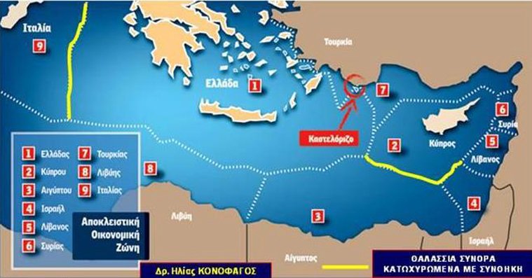
Kastellorizo or Megisti is located in the southeastern Mediterranean, roughly 2 kilometres (1 mile) off the south coast of Turkey, 125 km (78 mile) east of the island of Rhodes.
A Greek island in the middle of Turkey’s vision of Exclusive Economic Zone as delimited with the Libya Agreement? Ankara cannot help but challenging this.
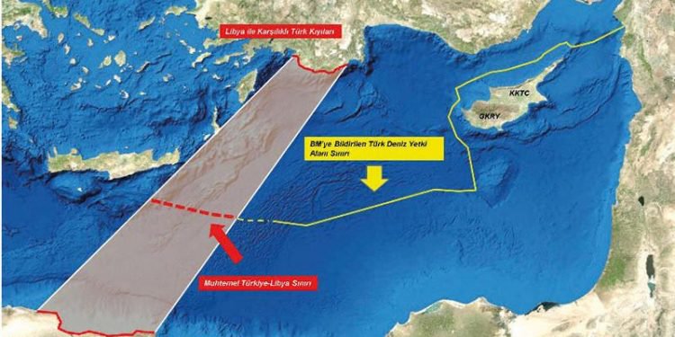
Monday noon, a high-ranking official at the Turkish Foreign Ministry tweeted a map of “Turkey’s CS/EEZ Outer Boundaries in the EastMed.” Ankara’s vision deprives East of Crete, Karpathos and Rhodes of Greek territorial waters and “swallows” Kastellorizo.
Türkiye'nin Doğu Akdeniz'deki KS/MEB sınırları:
(A-B)2011 TC-KKTC Anlaşması
(C-D-E) ??-?? ana karalar arası ortay hat
(E-F)2019 ??-??AnlaşmasıTurkey's CS/EEZ Outer Boundaries in the EastMed:
(A-B)2011 TR-TRNC Agr.
(C-D-E) Median line between ??&?? mainlands
(E-F)??-??Agreement pic.twitter.com/tSTXjucLU7— Çağatay Erciyes ?? (@CErciyes) December 2, 2019
“Turkey’s insistence on trying to abolish the maritime zones of the islands – such as Crete, Rhodes, Karpathos, Kastelorizo - or even entire islands-groups, with tricks such as invalid bilateral memoranda that, by magic, are suddenly or by selectively invoking court decisions or articles of UNCLOS – to which it refuses to adhere – does not produce internationally legal effects,” the spokesmand of the Greek Foreign Ministry said on Monday morning.
Turkey cannot challenge “the sovereign rights of our islands, which are undoubtedly established in international law and, in particular, in the international Law of the Sea,” the spokesman said adding “instead of talking about the position of islands on the “wrong side of the middle line”, we invite Turkey to ask itself whether it wants to be on the wrong side of the Law.”
Foreign Minister, Nikos Dendias, reiterated that the Turkey-Libya Agreement was “unacceptable” and threatened anew the Libyan Ambassador to Athens with expulsion should he not reveal the content of the agreement by Thursday, Dec 5.
While in Cairo on Sunday, Dendias discussed the Agreement with his counterpart, Sameh Shoukry.
Following the meeting, Dendias said that both countries think that the international recognized government of Libya “probably lacks the necessary legitimacy to sign such memorandums of understanding.”
Greece and Egypt agreed to accelerate the discussions between the technical teams on characterization and delimitation of the Exclusive Economic Zones between the two countries, Dendias stressed.
An Exclusive Economic Zone (EEZ) is a sea zone prescribed by the 1982 United Nations Convention on the Law of the Sea over which a state has special rights regarding the exploration and use of marine resources, including energy production from water and wind. It stretches from the baseline out to 200 nautical miles (370 km) out from its coastal baseline.
The exclusive economic zone stretches much further into sea than the territorial waters, which end at 12 nmi (22 km) from the coastal baseline (if following the rules set out in the UN Convention on the Law of the Sea). Thus, the exclusive economic zones includes the contiguous zone. States also have rights to the seabed of what is called the continental shelf up to 350 nmi (650 km) from the coastal baseline, beyond the exclusive economic zones, but such areas are not part of their exclusive economic zones. The legal definition of the continental shelf does not directly correspond to the geological meaning of the term, as it also includes the continental rise and slope, and the entire seabed within the exclusive economic zone.
The exception to this rule occurs when exclusive economic zones would overlap; that is, state coastal baselines are less than 400 nmi (740 km) apart. When an overlap occurs, it is up to the states to delineate the actual maritime boundary.
The exception to this rule occurs when exclusive economic zones would overlap; that is, state coastal baselines are less than 400 nmi (740 km) apart. When an overlap occurs, it is up to the states to delineate the actual maritime boundary. Generally, any point within an overlapping area defaults to the nearest state.
Published at https://www.keeptalkinggreece.com/2019/12/02/turkey-kastellorizo-greece-eez/


