Sep 3, 2023
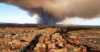
Latest satellite data made available today by the Rapid Mapping Service Copernicus of the European Commission, for the largest forest fire of the last many years on European territory in Evros.
According to the analysis of the satellite data, the total area burned by the forest fire of Evros, which resulted from the combination of the fires in Alexandroupolis and Dadia, exceeds 935.000 hectares (up to 02.09.2023, 11:31 local time).
Out of the total 935.000 acres of burnt area, we roughly have these three numbers:
- 440.180 str concern forest lands (47%).
- 318.700 str concern bush lands (34%).
- 81.140 str concern agricultural lands (9%).
Visualization of the burnt area was carried out by the unit FORECAST of the National Observatory of Athens.
Terrifying spread of the burned area in two 24 hours
It is recalled that meteo in a recent publication showed the evolution of the burnt area from satellite images in the great fire in Evros.
The images as captured by the Copernicus Rapid Mapping Service of the European Commission, of the largest forest fire of the last many years on European soil in the Evros, were particularly disturbing.
The fire started on 19.08.2023 and continues to burn until today, having active foci around the burned areas.
The following video (animation) shows the evolution of the burned areas from the day the fire broke out until 29.08.2023.
Also read
BBC: The fires in Greece among the extreme weather phenomena that hit the planet this summer
We remind our readers that publication of articles on our site does not mean that we agree with what is written. Our policy is to publish anything which we consider of interest, so as to assist our readers in forming their opinions. Sometimes we even publish articles with which we totally disagree, since we believe it is important for our readers to be informed on as wide a spectrum of views as possible.


