Satellite Images Ignite Alarm Over ‘Unprecedented’ Scale and Planet-Heating Emissions of Raging Arctic Wildfires
Carbon dioxide emitted by Arctic fires in June and July, according to one expert, “is getting close to 2017 fossil fuel CO2 emissions of Belgium.”
by
On the heels of several studies revealing that last month was the hottest June in recorded history, new satellite images show that wildfires in the Arctic Circle this month have reached what multiple experts have called “unprecedented” levels—elevating concerns about the planet-heating emissions produced by the blazes.
Satellite photography expert Pierre Markuse has processed and posted to Flickr and Twitter images of recent fires raging across Alaska, Canada, Greenland, and Siberia. Monday, he published the latest batch, featuring images captured on July 21.
Several wildfires? and smoke between about 62°N and 69°N in #Alaska, #USA??, and the #YukonTerritory, #Canada?? 22 July 2019 Enh. nat. col. with hot spots #Aqua?️ #Terra?️ #MODIS Full-size: https://t.co/UGgaX8LpaD #Wildfire album: https://t.co/5IqDrkAjrV #RemoteSensing pic.twitter.com/JYevd1nnjG
— Pierre Markuse (@Pierre_Markuse) July 23, 2019
Thermal anomalies registered by #Aqua?️ and #Terra?️ #MODIS and #SuomiNPP?️ #VIIRS (all 21 July 2019) show hot spots in that area, further indicating that it is still smoldering/burning. Thanks to @jmccarty_geo for pointing it out to me! #RemoteSensing 2/2 pic.twitter.com/d5Cp88IiuM
— Pierre Markuse (@Pierre_Markuse) July 22, 2019
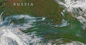
Look at the many wildfires? and smoke plumes between 57°N and 70°N in #KrasnoyarskKrai and #SakhaRepublic, #Russia?? 21 July 2019 Enh. nat. col. with hot spots #Aqua?️ #Terra?️ #MODIS Full-size: https://t.co/tCHbwXFRxb #Wildfire album: https://t.co/5IqDrkAjrV #RemoteSensing pic.twitter.com/eLpc03sSjR
— Pierre Markuse (@Pierre_Markuse) July 22, 2019
Alaska, as Common Dreams reported earlier this month, is enduring an unusual heat wave that experts connected to the climate crisis. On July 4, the temperature in Anchorage soared to 90°F, an all-time record. This year alone, wildfires have already destroyed more than 1.6 million acres of land in the state.
Reporting on Markuse’s new images Monday, The Independent noted that “the pictures show forest fires and burning peat.”
In a piece last week that highlighted some of Markuse’s earlier images, Earther explained that the Siberian peatlands are “normally frozen or soggy.” However, “there are ample signs the peat dried out due to the heat and is ablaze. That’s worrisome since peat is rich in carbon, and fires can release it into the atmosphere as carbon dioxide.”
Both the World Meteorological Organization (WMO) and Europe’s Copernicus Atmosphere Monitoring Service (CAMS), in statements earlier this month, described the Arctic Circle fires as “unprecedented.” CAMS senior scientist Mark Parrington, an expert on wildfire emissions, repeated the term in a series of tweets Monday.
The carbon dioxide emitted by Arctic fires between the beginning of June and July 21, according to Parrington, “is getting close to 2017 fossil fuel CO2 emissions of Belgium.”
Approximately 100 Mt CO2 emitted by Arctic wildfires between 1 June & 21 July 2019 is getting close to 2017 fossil fuel CO2 emissions of Belgium https://t.co/ulk5y0IJh6 @EU_ScienceHub @adamvaughan_uk
— Mark Parrington (@m_parrington) July 22, 2019
The July 11 statement from CAMS detailed six weeks of findings from tracking “over 100 intense and long-lived wildfires in the Arctic Circle.”
“In June alone, these fires emitted 50 megatons of carbon dioxide into the atmosphere, which is equivalent to Sweden’s total annual emissions. This is more than was released by Arctic fires in the same month between 2010 and 2018 put together,” the statement said. “Although wildfires are common in the northern hemisphere between May and October, the latitude and intensity of these fires, as well as the length of time that they have been burning for, has been particularly unusual.”
CAMS data from the past two decades shows that in the Arctic Circle specifically, fires are most common in July and August. As Parrington put it: “It is unusual to see fires of this scale and duration at such high latitudes in June… But temperatures in the Arctic have been increasing at a much faster rate than the global average, and warmer conditions encourage fires to grow and persist once they have been ignited.”
Warming temperatures also coincide with rare fire activity in Greenland. Earther reported:
A landscape known more for its ice, this is the second time in the past three years a wildfire has ignited in western Greenland. There are very few historical precedents for these types of blazes, and though they’re not on the scale of what’s happening in Siberia and Alaska, they’re yet another symptom of an Arctic transitioning into a more volatile state as the planet warms.
Referencing research published in the past decade on the broader trend of more common and devastating fires in the coldest regions of the planet, Earther added, “the boreal forest that rings the northern portion of the world is witnessing a period of wildfire activity unseen in at least 10,000 years, and this summer is another worrying datapoint.”


